

Victoria's gold-bearing rocks are sandstones, siltstones and mudstones, deposited in deep marine conditions some 400 million years ago. Today they form a bedrock spine that runs east to west through Victoria, with the Great Divide running along the crest of Victoria's Western and Eastern Uplands.
Multimedia Content
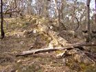
Middletons Creek Reef, Castlemaine Diggings National Heritage Park
Details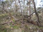
Nuggetty Reef, Castlemaine Diggings National Heritage Park
Details
English author turned digger William Howitt predicts the devastation mining will bring, courtesy of Longman, Brown, Green and Longmans.
Details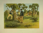
Surveyors, by Gill, Samuel Thomas (1818 - 1880), courtesy of Ballarat Fine Art Gallery.
Details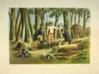
Splitters, by Gill, Samuel Thomas (1818 - 1880), courtesy of Ballarat Fine Art Gallery.
Details
Geology and Environment: Overview
Details
The gold is associated with veins of milky white quartz which were intruded into the older rock after it had been uplifted, drained, folded and faulted.
In the late nineteenth century, deep mine shafts were dug to extract the gold ore, which then had to be crushed and treated to free the gold. Today this type of gold mining continues at Stawell, Ballarat and Bendigo, and requires large investments of money for machinery and employment.
The first gold found in Victoria was in stream sediments (alluvium) and this alluvial gold, often fine flakes but sometimes in large nuggets, had been carried by running water from weathered profiles formed over many millions of years on the old bedrock. Along the streams and valleys of mid-nineteenth century Victoria, prospectors panned for evidence of gold, and concentrated it by washing the alluvium in pans and cradles. Alluvium was dug from the stream beds, and adjacent terraces, sometimes using shallow shafts to reach the heavy gold which accumulated at the bottom of the deposits.
Older alluvial deposits also contained gold. These had been deposited in valley-bottoms, but over time had been left high along valley sides, and sometimes as hilltop and plateau cappings, as the teams cut further into the rocks. The White Hills Gravels to the east of Bendigo are a good example. These sands, clays and gravels had often been cemented with iron and other materials over time, and were commonly referred to by miners as Hard Hills. To break them up and allow the gold to be concentrated, the deposits were sluiced with high-pressure water. This required some capital investment, and generally occurred after more accessible stream deposits had been exhausted.
Alluvial deposits of gravel, sand and clay of intermediate age, similar to the White Hills Gravels, but occurring lower in the landscape, had often sometimes been buried by lava flows from the many volcanoes which were active in the Uplands between 5 million and half a million years ago. These deposits were known as deep leads, and to reach the gold, shafts had to be sunk through the hard basalt lava capping into the underlying alluvium. This required major capital investment, not only for labour and equipment, but also to control the groundwater which generally filled the old buried stream deposits. In areas such as Creswick, the broad lava plains are today still dotted with mullock heaps near the many shafts sunk along the lines of the old buried deep lead drainage.
Large supplies of wood were needed for shaft props, and to power the steam engines which ran the lifting cables, pumped the underground water, and crushed the ore for chemical treatment. Much of the local Box-Ironbark woodland and forest were rapidly destroyed. In turn this triggered soil erosion, as did the many roads, tracks, buildings and other mining activity.
Also significant was the runoff from the panning, cradling, sluicing and chemical treatment of gold ore. The sand and clay, and the fine silt from the crushing of gold ore, was carried down streams and deposited in the lower parts of the landscape, forming a sheet sometimes often half a metre thick. This material spread over broad areas where the Upland streams ran out onto the plains of the Murray Basin to the north, and the Western Plains to the south. Today along streams this deposit of Post-Contact Deposits forms a broad and thin blanket over the old soil, burying tree roots, old fences and sometimesold mining relics. Even today, this deposit is sometimes misidentified as a soil, although it contains little in the way of organic matter or nutrients.
- References
- , http://www.ballarat-goldfields.com.au/. Details
- Blainey, G., Our side of the country: the story of Victoria, Methuen Haynes, Sydney, 1984. Details
- Joyce, E.B. et al, 'Geomorphology, the evolution of Victorian landscapes', in Birch W. D. (ed.), Geology of Victoria, Geological Society of Australia Special Publication No. 23, Geological Society of Australia (Victoria Division), 2003, pp. 533-561. Details
- Joyce, E.B., 'The West Victorian Uplands: origin and history.', Earth Surface Processes and Landforms, no. 17, 1992, pp. 407-418. Details
- Kotsonis, A. & Joyce, E.B., The regolith of the Bendigo 1:100 000 map area, Victorian Initiative for Minerals and Petroleum Report 77, Department of Primary Industries, 2003. Details
- Peterson, L. F., Reading the Landscape: documentation and analysis of a relict feature of land degradation on the Bendigo District, Monash Publications in Geography and Environmental Science 48, 1996. Details
- Phillips, G.N. and M. J. Hughes (Coordinators), D. C. Arne, F. P. Bierlein, S. P. Carey, T. Jackson and C. E. Willman, 'Gold - historical wealth, future potential', in Birch, W.D. (ed.), Geology of Victoria, Geological Society of Australia Special Publication No. 23, Geological Society of Australia (Victoria Division), 2003, pp. 377-432. Details