


Located on the Loddon River the township of Baringhup was surveyed and proclaimed in 1859. The 1871 census collector noted that the town was on the river’s eastern side (East Baringhup) and that the western side contained several scattered mining centres. Between 1861 and 1891 Baringhup’s population remained constant at around 40 but had increased to 122 by 1901.
Multimedia Content

Where is Baringhup located?
Details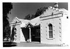
Loddon House, Baringhup, by John T. Collins, 1907-2001 (photographer), courtesy of State Library of Victoria.
Details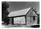
Former bakehouse at Loddon House, Baringhup, 16 January 1976, by John T. Collins, 1907-2001 (photographer), courtesy of State Library of Victoria.
Details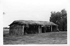
Thatched shed on Maldon-Dunnolly Road near Baringhup, 1 June 1980, by John T. Collins, 1907-2001 (photographer), courtesy of State Library of Victoria.
Details
Baringhup, VIC
- References
- Watson, A.B., The lost & almost forgotten towns of colonial Victoria, A.B. Watson, 2003. Details