


First settled by the pastoralist Captain Hepburn, Yandoit is located about 20 kilometres north of Daylesford. In 1854, rich alluvial gold was discovered in Nuggetty Gully and later along the tributary gullies of the Yandoit Creek. The area was rushed by an estimated 5,000 diggers but gold quickly petered out. Deep lead mining began in 1858 and, by the late 1860s, Yandoit was supported by a mixture of farming and mining. Many Italians and Swiss-Italians settled in and around the town and built many of its surviving local stone buildings. Yandoit was surveyed in 1861 and proclaimed in 1885. Its population in 1861 was 232, but had declined to 77 by 1881.
Multimedia Content
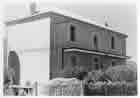
'Locarno', Yandoit, by John T. Collins, 1907-2001 (photographer), courtesy of State Library of Victoria.
Details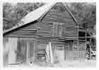
Former Cobb & Co stables, Yandoit, by John T. Collins, 1907-2001 (photographer), courtesy of State Library of Victoria.
Details
The Old Stone House at Pine View, Yandoit, 2002, courtesy of State Library of Victoria.
Details
Yandoit, VIC
- References
- The traveller’s guide to the goldfields: history & natural heritage trails through central & western Victoria, Best Shot! Publications Pty. Ltd, Torquay, 2006. Details
- Gervasoni, C., Bullboar, Macaroni & Mineral Water, Hepburn Spring Swiss Italian Festa Inc., Hepburn Springs, 2005. Details
- Watson, A.B., The lost & almost forgotten towns of colonial Victoria, A.B. Watson, 2003. Details